OregonQuake

Oregon’s biggest earthquake hasn’t happened yet.

One sinking plate drives most of Oregon’s hazards: the Cascadia earthquake, the tsunami behind it, landslides it shakes loose, and the volcanoes it feeds. Here’s how they fit together. Select any label to learn more.

Cutaway of Oregon, ocean to high desert, looking north along the Cascades The Juan de Fuca plate sinks east beneath Oregon. Where it is locked offshore, it builds strain for a magnitude 9 earthquake and tsunami. Water released from the sinking plate lowers the melting point of the mantle above it, forming magma that feeds the Cascade volcanoes. Behind the slice, Mount Jefferson, Mount Hood, Mount St. Helens and Mount Adams recede to the north, and the Willamette River flows north to Portland. The Coast Range is prone to landslides, the valley’s soft soils amplify shaking, and eastern Oregon has its own crustal faults. Mount Hood (Wy’east), 11,249 ft, is Oregon’s tallest peak. Its last eruptions were in the 1780s and 1790s, and USGS ranks it among the nation’s highest-threat volcanoes. Mount Hood Mount Jefferson, 10,497 ft, is Oregon’s second-tallest peak. Mount Jefferson Mount St. Helens, Washington. Its May 18, 1980 eruption was the deadliest and most destructive in U.S. history. St. Helens Mount Adams (Pahto), Washington, over 12,000 ft. A huge but quiet volcano. Adams Marys Peak, 4,097 ft, is the highest point in Oregon’s Coast Range. Marys Peak The Willamette flows north to the Columbia at Portland. Most Oregonians live in its valley, on soft soils that amplify shaking. Willamette River, north to Portland A Cascadia rupture lifts the seafloor and pushes up the whole water column. The first waves can reach the coast within minutes. Tsunamiminutes, not hours Offshore, the plates are stuck together. Strain has built since the last rupture in 1700. When it lets go, expect magnitude 9 shaking for up to five minutes. Locked faultstuck since 1700, building toward M9 The Juan de Fuca plate moves northeast about 3 to 4 cm a year, roughly as fast as your fingernails grow, and dives beneath North America. This is subduction. Juan de Fuca platesinks east ≈ 4 cm/yr If the ground shakes hard at the coast, don’t wait for a siren. Walk inland or uphill as soon as the shaking stops. Head uphillshaking is the warning Slope and behold: the Coast Range’s steep, rain-soaked hills slide every winter, and a big quake will trigger thousands of slides at once. LandslidesCoast Range The Willamette Valley sits on deep, soft river sediment. It amplifies shaking, and wet sand can turn to slurry during a quake. That’s liquefaction. Soft valley soilsshake harder, can liquefy This slice cuts through the Three Sisters. Since the late 1990s, the ground west of South Sister has slowly bulged, a sign of magma moving deep below. Three SistersCascade volcanoes A lahar is a volcanic mudflow. Melted snow and ash can race down river valleys for tens of miles, far beyond the mountain itself. Lahar About 100 km down, heat and pressure squeeze water out of minerals in the sinking plate. That water rises into the hot mantle and lowers its melting point, the way salt melts ice, so some rock melts. The melt is magma. It rises, pools beneath the volcano, and sets off small quakes as it moves, which is how the USGS gets weeks of warning before an eruption. Magma forms herewater from the plate lowers the melting point Not every Oregon quake comes from Cascadia. Shallow crustal faults caused the 1993 Scotts Mills (M5.6) and Klamath Falls (M5.9 and M6.0) earthquakes. Crustal faultsKlamath Falls 1993, M6.0
Loading the last seven days of quakes…

What’s shaking now

Map: VolcanoDiscovery. Quake list: USGS, M1 and up in Oregon and offshore (M2 and up for 30 days).

Prepare for Oregon’s hazards

Preparedness and good engineering have saved millions of lives in places with frequent, strong earthquakes. Many Oregon communities also face high landslide risk, and coastal towns face tsunamis.

Cascadia earthquake

A 600-mile fault runs 70 to 100 miles off the coast, from northern California to British Columbia. When it slips, expect strong shaking across western Oregon for minutes, not seconds, then aftershocks for months. Roads, bridges, water and power may be out for weeks.

  1. Drop to your hands and knees.
  2. Cover your head and neck, under a sturdy table if one is close.
  3. Hold on until the shaking stops.

Using a cane, walker or wheelchair? Lock your wheels, get as low as you safely can, and cover your head and neck.
Landslides and debris flows

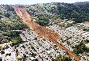
Oregon’s steep, wet terrain slides every winter, and a big earthquake will trigger thousands of slides at once. Burn scars from recent wildfires are especially prone to fast debris flows during heavy rain.

  • Watch for new cracks, tilting trees or fences, and doors that suddenly stick.
  • During intense rain, listen for rumbling and watch for creeks that suddenly turn muddy or stop flowing.
  • Check whether you live on or below a mapped slide with DOGAMI’s SLIDO map.

Volcanoes

Mount Hood is dormant, not retired. Hood, Jefferson, the Three Sisters, Newberry and Crater Lake could all erupt again. Eruptions usually come with weeks of warning from earthquakes and ground swelling. The biggest dangers are ash and lahars: volcanic mudflows that follow river valleys far from the mountain.

  • If you live in a valley below a volcano, know your route to higher ground.
  • Keep N95 masks and eye protection in your kit for ashfall.
  • Follow the USGS Cascades Volcano Observatory for alert levels.

Tsunami: know your way out

When the ground shakes

If you’re on the coast and the ground shakes hard, that is your warning. Once the shaking stops, walk inland or uphill right away. Don’t wait for a siren or an alert. Waves can arrive within minutes and keep coming for hours.

  • Learn your evacuation route on foot before you need it, from home, work and anywhere you vacation.
  • A distant tsunami from Alaska or Japan gives hours of notice. Follow official alerts for those.
  • Stay on high ground until officials give the all-clear.

Find your evacuation zone

Map by NANOOS. Search an address, or open it full screen.

2 Weeks Ready checklist

After a Cascadia quake, help may take weeks to reach you. Oregon emergency managers recommend enough supplies to get your household through two weeks. Your checks are saved in this browser only.

Water and food
Health and sanitation
Power and comms
Home and go-bag

Resources

Oregon quake news

  • Loading…
More on Google News

On Bluesky

  • Loading…
Follow @oregonquake.bsky.social

About and privacy

OregonQuake is an independent awareness project, not a government agency. In an emergency, call 911 and follow your local officials.

This site sets no cookies and runs no analytics or ads. Your checklist and your light or dark setting are stored only in your browser. The page loads data from USGS and Bluesky, fonts from Google Fonts, and embedded maps from VolcanoDiscovery and NANOOS, our partners in getting the word out.